Iceland Ring Road Itinerary 8 Days: The Ultimate Self-Drive Guide

Planning your Iceland Ring Road trip and trying to figure out the best stops, how far to drive each day, or what’s actually worth squeezing into an 8 day itinerary? When James and I drove the full Ring Road, I had all the same questions, and it ended up being one of our favourite trips ever.
I’d wanted to visit Iceland for years, ever since watching The Secret Life of Walter Mitty and seeing that scene where he zig-zags down the mountain on a skateboard. Not my vehicle of choice (but how cool would that be?), but it was enough to put Iceland right at the top of my list.
The island honestly lived up to every expectation. Iceland is just ridiculous in the best way! Volcanic beaches, thundering waterfalls, steaming hot springs, glacier lagoons… it’s a road trip playground for anyone who loves wild, dramatic scenery.
On our trip, we figured out which places are genuinely worth the hype, which ones you can skip, and the route that actually works when you’ve only got just over a week.
This guide shares our exact 8-day Iceland Ring Road itinerary from where to go, where to stay, how long to spend in each spot, and the stops I’d 100% do again, from the black sand beaches of Vík to the geothermal magic up in Hverir.

Iceland Ring Road Itinerary 8 Days At A Glance
If you’re in a rush, this is a quick overview of what you’ll find in this 8-day Iceland guide.
Is 8 Days Enough Time To Explore Iceland’s Ring Road?
Although Iceland is pretty small in comparison to some other countries, there is a lot to see and do! After our visit, I can totally see how some people can spend 3 weeks here, especially if you were to include the highlands as part of the trip. But to see the main sights around the Ring Road, an 8-day Iceland itinerary will be enough time.
If you don’t have enough time to explore the Ring Road, I’ve written this 5-day Iceland guide that takes you to the best places along the south coast.

What Time Of Year Is Best For A Road Trip Around Iceland’s Ring Road?
If you ask me, Iceland is going to be beautiful all year round, and whenever you visit,t there will be plenty to see.
That being said, to drive the Ring Road, you’ll want to visit during the summer months of May to August, when there is less risk of snow and bad weather. The worst time to explore Iceland on a self-drive itinerary will be the winter months of November to March. The days in winter are also very short, so you will be limited on how much you can see.
We visited Iceland in July as I really wanted to see the lupins and the midnight sun, and although we had a couple of drizzly days, the weather was good to us for the rest of the trip.
What’s The Total Distance Of Iceland’s Ring Road?
Iceland’s Ring Road is 1332 kilometres (828 miles) long and loops around most of the island. It’s also known as R1 or Route 1.
It does exclude a few places, such as the West Fjords and Snæfellsnes Peninsula, but we managed to squeeze a detour to Snæfellsnes on the eighth day of this itinerary.
You can drive the Ring Road either clockwise or anti-clockwise, both directions take the same amount of time. This guide will take you anti-clockwise, but you can start on day 8 and work your way backwards if you prefer to go the other direction.

What To Know Before You Set Off On A Road Trip In Iceland
Before you set off on your 8 days in Iceland trip, there are a few things to know about any Ring Road itinerary. First off, Iceland is a very expensive country to visit, even more expensive than England and believe me, that’s saying something!
You can cut costs in a few ways, such as renting a camper and staying in campsites instead of renting a car and paying for accommodation. This might not be everyone’s cup of te,a but we really enjoyed exploring this way. We also packed some dry food and snacks in our luggage to keep some costs down.
Many of the natural sights in Iceland are free to visit, but you will need to pay for parking at most of these locations.
Most Icelanders speak English if you need to ask for directions and road signs around the Ring Road are pretty easy to follow. Check travel, weather and road updates at these sites before starting out on each day; road.is, safe.is and vedur.is. If you don’t have a travel buddy, you’ll be pleased to know that Iceland is also one of the safest places for solo travel.
8 Day Iceland Ring Road Itinerary
Iceland Itinerary Day 1

If you can, try to book a flight that lands early in the morning so you have the whole of day 1 to explore. Most car and camper rentals open at around 9 am so head to pick up your rental as soon as you land.
Reykjanes Peninsula
The Reykjanes Peninsula is really close to Keflavík Airport and Reykjavík, making it the perfect place to kick off your Iceland road trip. Like many other parts of Iceland, it’s a geologically active region characterised by rugged lava fields, geothermal areas, and dramatic coastal cliffs.
It’s also home to Iceland’s oldest lighthouse as well as the Bridge Between Continents, where the Eurasian and North American tectonic plates meet. When we visited in July 2023, the Litli-Hrútur eruption had just begun,n which I was so excited about, talk about timing our trip well! During this time, visitors were allowed to hike out to see the volcano, which later stopped erupting on 5th August 2023.
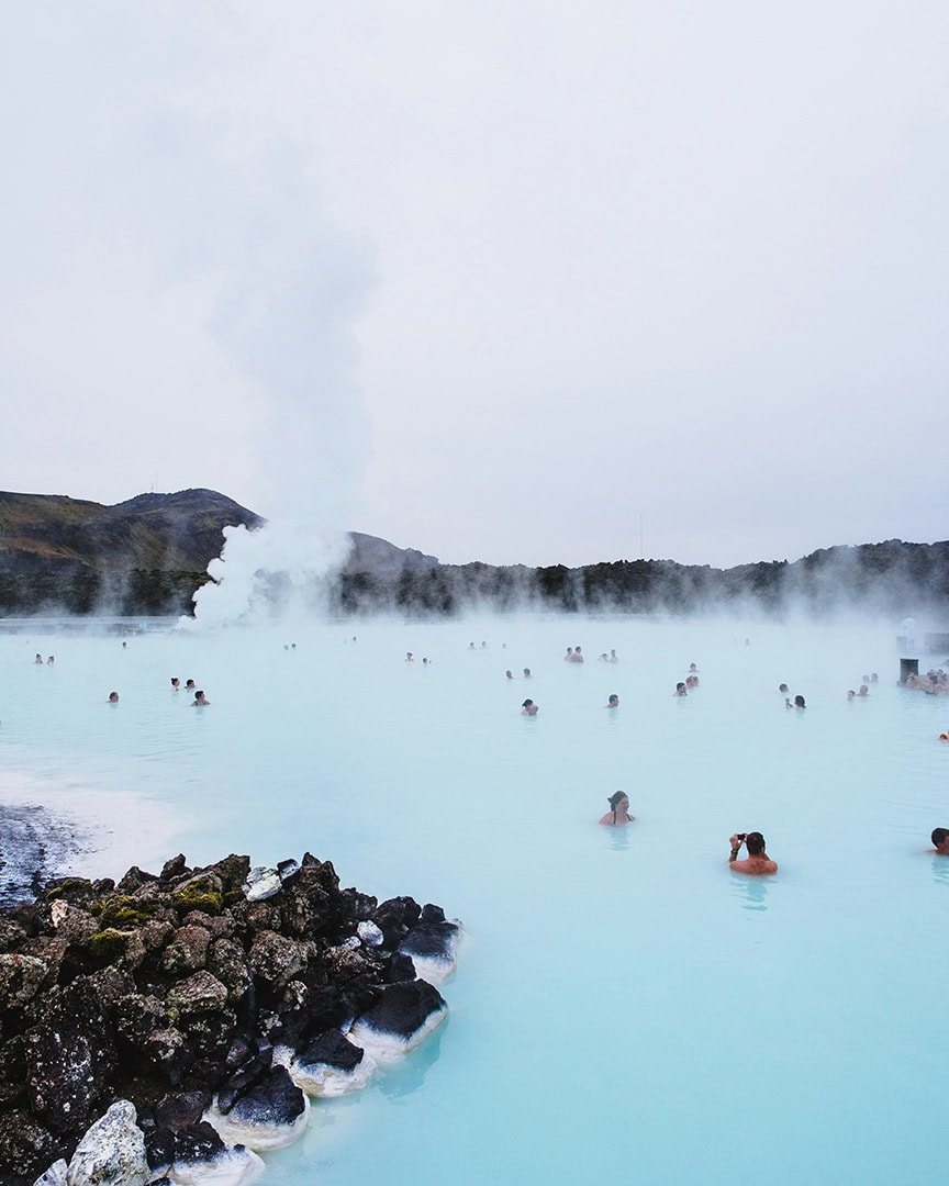
The iconic Blue Lagoon is also found in Reykjanes, and this is one of Iceland’s most popular attractions.
Note: There has been a series of volcanic activity in the Svartsengi area of the Reykjanes Peninsula. While some areas of the peninsula are still accessible, this specific area remains closed. Before your trip, check for up-to-date information on closures and safety advice at Visit Reykjanes and Safe Travel.

Reykjavík
After an afternoon of exploring, head to the colourful town of Reykjavík where you’ll find some great shops, bars and places to eat (I even found some tasty vegan restaurants too!).
If you head up Rainbow Street, you’ll get a great view of Hallgrimskirkja Church. You can also enter Hallgrimskirkja and go to the 8th floor for a panoramic view of Reykjavík.
I’ve visited both the Blue Lagoon and the Sky Lagoon while in Reykjavik, and I’ve written a post all about which spa I think is better — and you might be surprised by my pick!
Where To Stay In Reykjavík
Hotel: Exeter Hotel
Hostel: Kex Hostel
Campsite: Reykjavík Eco Campsite
If you’ve got a spare day in Reykjavík, a responsible whale watching tour is also a good shout. This is the tour I went on, and honestly? We absolutely loved it.
Iceland Itinerary Day 2

On day 2 of this itinerary, you’ll leave Reykjavík to go and explore Reykjadalur Hot Spring and parts of the Golden Circle. You’ll then head along the south coast to see some of Iceland’s most iconic waterfalls.
Reykjadalur Hot Spring
The Reykjadalur Valley is about a 45-minute drive from Reykjavík, followed by an hour’s hike to reach the hot springs. I’d suggest starting the day as early as possible to make the most of it and to beat the crowds.
The hike begins with an uphill climb for the first 20 minutes, then flattens out for the rest of the walk. Along the trail, you’ll pass steaming hills, bubbling mud pools, and get a pretty decent view of Djúpagilsfoss waterfall.
You’ll know you’ve reached the bathing area when you see a wooden path and a few wooden partitions for changing. I found that some parts of the river were warmer and deeper than others, so you might need to move around to find the perfect soaking temperature. The rocks can be very slippery, so watch your step.

Geysir
Geysir is the next stop of the day. Located in the Golden Circle it’s one of Iceland’s most famous geothermal attractions. While the Great Geysir itself is mostly dormant, its neighbour Strokkur erupts every 5-10 minutes, shooting hot water up to 30 meters in the air.
The walk from the car park is only a few minutes, making it easy to access.
Gullfoss
Probably Iceland’s most visited waterfall, Gullfoss is a stunning two-tiered cascade located in the Golden Circle. It’s one of Iceland’s most recognised natural wonders, where the Hvítá River, fed by the Langjökull Glacier, plunges dramatically into a rugged canyon.
There are several different viewing platforms to see the falls from and there are also two parking areas, making it easy to access and explore.

Seljalandsfoss & Gljufrabui
The drive from Gullfoss to Seljalandsfoss takes about an hour and a half and is a good time to rest your legs after a morning filled with walking.
You’ll be able to see Seljalandsfoss gushing over the mossy cliffs from the Ring Road, and it’s just a short walk from the car park. The cool thing about Seljalandsfoss is that you can walk all the way around it.
The pathway leads you behind the waterfall, which is a great photo spot. If you walk behind the waterfall, you will get wet! My not-so-waterproof jacket was absolutely soaked through. The path is also really slippery, so tread carefully.
Gljufrabui, which literally translates to ‘Canyon Dweller,’ is just a short 10-minute walk from Seljalandsfoss and is tucked away inside a cave. You can enter the cave through a small opening and get pretty close to the falls, but be prepared to get wet again!

Skógafoss
Your last stop of the day is Skógafoss, a waterfall that pours over the cliffs that were once Iceland’s coastline. The falls are so powerful that there is a constant mist, often creating a huge rainbow that arches over the river.
There are some steps to the right of the waterfall that you can climb to get some awesome views from the top of the falls. In the summer, there is also a massive field of lupins near Skógafoss where you can get some great photos with the falls in the background.
Where To Stay Near Skógafoss
Hotel: Hotel Skógafoss
Campsite: Skógar Campsite
Guesthouse: Guesthouse Skógafoss
Iceland Itinerary Day 3

Day 3 of your 8 day Iceland ring road itinerary kicks off with a short hike to one of Iceland’s oldest swimming pools. Next, you’ll explore one of the island’s lesser-known waterfalls before heading towards Reynisfjara Black Sand Beach and the quaint town of Vik.
Seljavallalaug Swimming Pool
Why not start your day with a short hike and a soak in the warm Seljavallalaug Swimming Pool? You would have passed this on your way to Skógafoss yesterday and will need to head 10 minutes back up the road, but it’s actually a nice place to begin your day.
The walk from the car park is only 25 minutes and will take you through a valley along the edge of a rocky river. The geothermal pool is at the foot of Eyjafjallajokull volcano and is surrounded by beautiful moss-covered hills.
When we visited in July 2023, the pool was filled with green algae which is not unusual for Iceland’s natural hot springs. As much as I enjoyed the relaxing soak, I wasn’t too keen on the slimy floor, just a heads up if you get grossed out by this sort of thing too! The changing rooms at the top of the pool were pretty derelict when we were there but from recent reviews, it looks like they’ve had a little spruce up.
If you keep walking along the path past the pool, you’ll also find a hidden canyon with a waterfall.

Kvernufoss
Kvernufoss is one of the south coast’s lesser-known waterfalls and is actually just a few minutes from Skógafoss. This was the quietest location we visited during our 8 days in Iceland and we didn’t see a single soul the whole time we were here.
The falls are hidden at the top of a canyon, and the scenic walk from the car park takes around 15 minutes. There is a path that leads you around the back of the falls, where you can look down through the canyon you walked through.
Dyrhólaey
Just half an hour up the road from Kvernufoss is Dyrhólaey, a volcanic peninsula that was once an island before joining the mainland. You can drive to either of the two car parks: the upper section and the lower section.
The upper section offers sweeping views over Endless Beach, Dyrhólaey Lighthouse, and the Dyrhólaey Arch. The lower section provides the best view of Reynisfjara Black Sand Beach. You can walk between the two sections or drive.
In the summer months, puffins nest here so make sure you have a telephoto lens for your camera!

Reynisfjara Black Sand Beach
Even though you can see Reynisfjara Black Sand Beach from Dyrhólaey, you’ll need to drive back to the main road and loop around to reach it.
Reynisfjara is one of the most dramatic-looking beaches in Iceland, its dark volcanic shores are backed by tall basalt columns with rugged sea stacks reaching out of the ocean. You do need to be careful of the tides here, as the sneaker waves are much stronger than they look.
Vík í Mýrdal
Vík í Mýrdal is a white and red church perched on a hill overlooking the small town of Vík and the ocean. It’s a really beautiful spot to visit at sunset or sunrise (the time of this will differ largely depending on the time of year you visit).
In the summer months, the views here are even more stunning as fields of purple lupins surround the church.

Vík
Vík turned out to be my favourite place where we camped for the night and the village had such a nice atmosphere. It’s the southernmost town on Iceland’s mainland and sits near the base of Katla volcano. Vik also has a black sand beach and is surrounded by mossy cliffs.
When I say I had the best coffee in all of our 8 days in Iceland here, I mean the best coffee!! Skool Beans is an old school bus that has been converted into a small coffee shop. They make a few baked goodies, a whole selection of drinks and also have a resident cat, what more could you want?
Because of Vik’s location, it’s a good place to pick up ice cave and glacier tours if you have the time.
Where To Stay In Vík
Hotel: Hótel Kría
Campsite: Vík Camping
Hostel: Vík HI Hostel
Iceland Itinerary Day 4

Today you’ll be driving through some of the scenery that puts the ‘ice’ in Iceland’s nickname, the land of fire and ice. Deep mossy canyons, giant glaciers, and iceberg-filled lagoons are just a few of the sights you’ll be seeing today.
If you can, start your day as early as possible. We spent a fair amount of time at each stop, and there is a good amount of driving involved.
Fjaðrárgljúfur
Apparently, even Icelanders find this a hard word to pronounce!
Fjaðrárgljúfur was a lesser-known location on the Ring Road until Justin Bieber featured it in one of his music videos. Since then, the deep green canyons of Fjaðrárgljúfur have been firmly on the map.
You’ll need about an hour here to walk the out-and-back trail to the final viewpoint.

Svínafellsjökull
Part of the Skaftafell Nature Reserve, Svínafellsjökull is one of the many outlet glaciers from Vatnajökull, the largest ice cap in Europe. This jagged river of ice is a popular spot for guided glacier tours, which will take you through stunning icy landscapes.
If you don’t feel like a glacier hike, there is a 15-minute walk from the car park that takes you really close to the glacier tongue. This is what we did, and we could still see just how huge the glacier is! If you listen carefully, you can hear the ice creaking.
Svartifoss
Part of the Skaftafell Nature Reserve and Vatnajökull National Park, Svartifoss, also known as the Black Falls, is one of Iceland’s most striking waterfalls (and that’s saying something!). It cascades down a cliff surrounded by dark basalt columns.
The walk is roughly 40 minutes each way, although you can take one of the longer routes if you prefer.

Jökulsárlón Glacier Lagoon & Diamond Beach
Jökulsárlón Glacier Lagoon and Diamond Beach are conveniently just across the road from each other so you can park at one location and explore both. These are some of my favourite spots on our 8 days in Iceland ring road itinerary.
The Jökulsárlón Glacier Lagoon is a huge lake backed by snowy mountains and dotted with piercing blue icebergs that have broken off the Breiðamerkurjökull Glacier.
These icebergs slowly make their way across the water before eventually being swept into the Atlantic. You’ll often see seals swimming between the huge chunks of ice or lounging on them having a snooze.
You can get closer to the icebergs by booking a boat tour or a kayaking tour.
Diamond Beach is a volcanic sand beach located on the other side of the road from the lagoon. Here, you can find thousands of polished fragments of ice sparkling like diamonds, dotted along the shores.
These chunks of ice are formed from the icebergs that float out from the lagoon. Once they are washed up, they can vary in size, from taller than you to tiny little shards.

Höfn
The small fishing town of Höfn, located on Iceland’s southeastern coast, has pretty views over the harbour and is backed by glacier-covered mountains. With plenty of options for accommodation and restaurants, it’s a great place to stop for the night.
We actually stayed just outside of Höfn and camped at the Viking Guesthouse.
Where To Stay In Höfn
Hotel: Milk Factory
Hostel: Höfn Hostel
Campsite: Viking Cafe & Guesthouse
Iceland Itinerary Day 5

Day 5 of your Iceland trip will take you along the east coast to more black sandy beaches, waterfalls, thermal baths that float on a lake, and one of my favourite towns in Iceland. You’ll be driving through some very beautiful landscapes, so make sure your camera batteries are charged!
Stokksnes Black Beach
This black sand beach has grass-covered sand dunes and is surrounded by jagged mountains, with the Vestrahorn being the most iconic of them. The landscape often looks moody and dramatic, making it a favourite spot for photographers.
When we were here on our 8-day Iceland ring road itinerary, we actually couldn’t see Vestrahorn, which I was so gutted about. It was super foggy that morning, and you could barely see a few meters in front of you. We later found out this was caused by the Litli-Hrútur volcano erupting.
Lækjavik
Found on the coast as you’re making your way along the Ring Road, Lækjavík is a beach framed by rugged cliffs with stunning views over the ocean. There is a single rock formation in the middle of the beach, making it a great spot for some cool photos.
You can walk down to the beach, but watch out for the strong waves.
Folaldafoss
A very short detour off the R1 will take you to Folaldafoss, a quiet and less visited waterfall along the Ring Road.
You’ll need to head up Road 939 and the parking area will be on your left. It’s just a 10-minute walk to reach the falls. Surrounded by rugged terrain and lush greenery, Folaldafoss feels like a hidden gem with a cascade that tumbles down rocky cliffs into a clear pool below.
Vök Baths
Found on the bank of Urriðavatn Lake, Vök Baths are a real treat after a day of travelling. These baths are different from any other hot spring in Iceland as the geothermal pools float on the lake!
The baths have two floating infinity pools, two on-shore hot pools, an in-water bar, a sauna and a cold water spray tunnel. There is also a bistro and tea bar onsite.
The geothermal water at Urriðavatn Lake is so pure that it’s the only drinkable hot spring water in Iceland.
You can book your entry ticket to Vök Baths here.

Seydisfjordur
Ok, I’m going to start by telling you I love Seydisfjordur and would have loved to stay here longer! Found at the top of a fjord that goes by the same name, this town has to be one of the most picturesque in Iceland.
The winding road that leads into Seydisfjordur is where the epic skateboard scene in the Secret Life of Walter Mitty was filmed. Obviously, we had the soundtrack playing on this part of our drive!
Surrounded by mountains and the ocean, the town’s colourful wooden buildings were built by Norwegian merchants in the late 1800s and are some of the most well-preserved in Iceland. One of these buildings you’ll probably recognise from Instagram is the blue wooden church with the rainbow path leading up to it.
I also found that Seydisfjordur had quite an artsy vibe, with some houses featuring vivid murals splashed across their walls.
Where To Stay In Seydisfjordur
Hotel: Við Lónið guesthouse
Hostel: Hafaldan HI Hostel
Camping: Seydisfjordur Camping Site
Iceland Itinerary Day 6

Day 6 of your 8 days in Iceland itinerary is packed with unique scenery along the northern part of the Ring Road. Returning to geothermal territory, you’ll see bubbling mud pots, lava fields and volcanic craters today. You’ll also see Europe’s most powerful waterfall and a once-hidden canyon.
Stuðlagil Canyon
Hidden beneath the waters of the Jökla River, Stuðlagil Canyon remained undiscovered until recent years. It was only when the water level dropped after the Kárahnjúkar Hydro Plant was activated in 2009 that this unusual canyon was revealed.
The dark basalt columns reaching out from the turquoise waters are the same as those found at Reynisfjara Beach, formed in a volcanic event many years ago.
To reach the canyon, you’ll need to park at this car park, as this is on the right side of the river and is the closest place to pick up the trail. The walk to the canyon is very pretty; it’s mostly flat and will take about 25 minutes to reach.
You can climb down into the canyon, but the rocks are very slippery, so you’ll need to watch your step. If you don’t want to hike into the canyon, this car park is a viewpoint over the canyon only.
Although this was an off-the-radar attraction for some time, by the time we went on our 8 day Iceland trip, Stuðlagil Canyon had become quite popular. We decided to visit before 7 am to avoid the crowds and were lucky to have it all to ourselves! However, on the hike back, we did pass quite a few people, and it did get busy.

Dettifoss & Selfoss
Known for being the most powerful waterfall in Europe, Dettifoss is just a short detour from the main Ring Road.
There are two parking areas to choose from: one to the east of the falls and one to the west. The east side offers better views of Dettifoss and you won’t get as wet from the spray, but it’s accessible only by a gravel road, which is better suited for 4x4s.
The west parking area is well-paved and has both upper and lower viewing platforms for great views of the falls. From either side, you can hike 1 km upriver to see the smaller Selfoss, framed by towering basalt columns.
To see both Dettifoss and Selfoss from the west car park, it’s a 2.5 km hike that takes about an hour. From the east side, the hike to both waterfalls is 2.5 km and takes around 1.5 hours.

Hverir
You’ll be able to smell Hverir before you see it!
If you can get past the strong smell of sulphur, this is actually a really cool place to explore. Hverir is a geothermal field where steam billows up from the ground and pools of mud boil and bubble.
There is a well-marked trail that will take you through the steaming hills and the orange landscape which looks like Mars.
Viti Lake
In Icelandic, the word ‘Viti’ directly translates to ‘hell.’
The lake earned its name from a belief among Icelanders that hell lay beneath the fiery volcanoes. Found on the Krafla Caldera, one of Iceland’s most volatile volcanoes, Lake Viti has piercing blue water that stands out against the surrounding brown landscape.
The car park is found at the crater edge and there is a short walk where you can see the lake.

Akureyri
I really enjoyed our afternoon in Akureyri and like with many of Iceland’s other towns it’s in a very scenic location.
Before heading into the main part of town, we made a quick detour to this hot spring that’s on the edge of a cliff and pours down into the ocean. This has some pretty views over Akureyri and the ocean, and we saw a whale while bathing here!
Akureyri is also known as the Capital of the North and has lots of cafes, restaurants and bars to enjoy for the evening.
Where To Stay In Akureyri
Hotel: Berjaya Iceland Hotels
Hostel: Akureyri Hostel
Campsite: Camping Hamrar
Iceland Itinerary Day 7

I’ll be honest, day 7 of your road trip along the Ring Road will be the longest drive on your 8 day Iceland itinerary. This is where you will make your way from the north of the island to the Snaefellsnes Peninsula.
Whale Watching in Akureyri
Before leaving Akureyri, why not book a whale-watching tour?
Akureyri is known as one of the best places to see whales in Iceland! Whale-watching tours take you through the beautiful Eyjafjord, where you can commonly spot Humpback Whales, Minke Whales, White Beaked Dolphins, and Harbour Porpoises.
Tours usually take between 2 – 3 hours.
Guðrúnarlaug
After a solid few hours of driving, I couldn’t think of a better way to stretch (or relax) your legs than a quick soak in a hot spring!
Guðrúnarlaug was the site of an ancient hot spring named after a heroine, Guðrún Ósvífursdóttir, from one of Iceland’s ancient sagas. The original pool is believed to have been destroyed by a landslide sometime in the 17th century but was rebuilt in 2009.

Stykkishólmur
Found in the northern part of the Snaefellsnes Peninsula, Stykkishólmur is a beautiful fishing town sitting on the edge of Breiðafjörður Bay.
The town is characterised by Iceland’s colourful wooden buildings and feels a bit like stepping back in time. Unfortunately, when we stayed the night here, the smog from the volcano erupting near Reykjavík meant that we couldn’t see just how pretty the town’s surroundings really were.
Where To Stay In Stykkishólmur
Hotel: Akkeri Guesthouse
Hostel: Sjávarborg
Campsite: Stykkishólmur Tjaldsvæði
Iceland Itinerary Day 8

It’s the final day of your 8 days in Iceland and your Ring Road itinerary!! The last stretch of this trip is where you’ll explore the Snaefellsnes Peninsula with views of the glacier-topped Snæfellsjökull Volcano.
Kirkufell
On your way to Kirkjufell, you’ll drive over Kolgrafarfjörður Bridge. This is a beautiful location with stunning views of the mountains in the background. If you have a drone, this is an awesome spot to get some aerial photos of the bridge winding across the water with the mountainous backdrop.
If you think you recognise Kirkufell, you’re not mistaken! Not only is it one of Iceland’s most photographed mountains but it was also featured in Game of Thrones as the Arrowhead Mountain.
Its unusual shape stands out behind the Kirkjufellsfoss waterfall and although it does get a little busy we enjoyed sitting by the river for a little while.

Svöðufoss
Somehow, Svöðufoss isn’t as popular as some of Iceland’s other waterfalls, which surprised me for a few reasons. First, it’s just a 30-minute hike from the car park to reach the falls, so it’s not too out of reach. Second, the waterfall is not only beautiful, pouring down basalt columns, but it also has the stunning backdrop of Snæfellsjökull Glacier.
I feel like some visitors are missing a trick by not visiting Svöðufoss but at least you won’t find hoards of other people here!
Búðakirkja
The drive to reach Búðakirkja from Svöðufoss will have more views across Snæfellsjökull Glacier, so you can expect to stop a few times on this leg of the journey.
Búðakirkja is different from the other churches you will have seen on your 8 days in Iceland as it is painted black and is found next to the Búðahraun lava field.
The little black church looks stark against the mossy landscape (or snow if you visit in the winter) and is another popular photo spot on the peninsula.
If you walk past the church the path will lead you to a gold sandy beach with views across the ocean.

Ytri-Tunga
The last stop before your drive back to Reykjavík is literally just off the main road.
Ytri-Tunga is one of the best places to see seals in Iceland, with harbour seals and grey seals being the most common. It’s just a short walk from the car park to the beach, but remember to keep a safe distance from the seals and avoid disturbing them.
From Ytri-Tunga it’s a 2 hour drive back to Reykjavík.
Final Thoughts: Iceland Ring Road Itinerary 8 Days: The Ultimate Self-Drive Guide
I absolutely loved this 8-day Iceland Ring Road itinerary and had the best time on this trip! Whether you’re exploring the land of fire and ice by camper van or rental car, there are plenty of camping and accommodation options for you to choose from.
I honestly don’t think exploring Iceland could be any easier than the Ring Road (weather permitting, of course!). From stunning waterfalls and dramatic landscapes to cosy towns and incredible wildlife, this route will take you on an unforgettable adventure!